
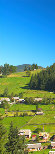
Bereziv
(Serediny, Vyzniy, Nyzhniy, Banya Bereziv, Bereziv) – the villages in Lyuchky valley in Carpathian Pokutians. A name already mentioned in 1405. In 1787, count Ignacy Cetner was the village leaseholder and since 1799, the owner. It was inhabited by 2500 people and in 1824 more than 3000. A lot of them were Polish nobles but afterwards speaking Russian. The villages were Berezivskiy clan with Sas as a family crest. The names of nobles are as follows Matkowycz, Genek, Symchych, Urbanovych, Drohomyrecki, Skulski, Solatytsky, Perkovych, Pidhorodetsky. Also in the sources the names of Jakub Hurbicz-Holynski and Franchyk Wande were mentioned. There was a noble community in Nyzhniy Bereziv and Vyzhniy since 16th century up to 1870. Seweryn Obst (1847-1917) one of the famous Hutsul painters was born there.
Bila Tysa
– the village on the bank of Bila Tysa, east of Rakhiv. It was inhabited by 3029 people in 1921. Two new orthodox churches in the center of village, several shops, the Border Guard station. Tourist base “Olesja”. A starting point to Pip Ivan Marmaroskyi (1937 m) and south Chornohora. A winter ski lift.
Burkut
– a well known spa over Chornyi Cheremosh (Black Cheremosh), near Chyvchynskyi Mountains, located over 1000 m, 40 km away from Zhabye. There are calcium-magnesium sources, known since 17th century. The name of Burkut means the sour source. In 19th century it was visited by Polish writers Józef Korzeniowski (the father of Joseph Conrad) and Wincenty Pol. In 1865 several spa buildings were built, destroyed during the World War PTT hostel opened in 1939. A forestry office. A starting point to Chyvchynskyi Mountains and Hrynyavski mountains.
Bystrets
(Bystrec) – Hutsul village in Bystrzets valley. It is established in 18th century as a hamlet of Kryvorivnya. Since 1927 as a part of Dzembronya community. A church of St. Anne sleep (1870). A starting point to mid Chornohora and Kostrycha range.
Delatyn
(Deljatyn) – a town and a community over Prut. A name already mentioned in 1370. The town located over 450 m.
Family Delatynsky nest since 15th century with the castle. Since 16th century owned by Betzecki family with 50 villages around. It was burnt out by the outlaws. In 1939 it was inhabited by 6000 people (with 4500 Ukrainians, as well as Jews and Poles) and a thousand visitors a year. The wooden orthodox church of Holy Mother from 1785, as well as the Roman-Catholic church of St Francis (1882). There were four synagogues there till 1939. In early 19th century a road along Jabtoncka pass to Hungary was built by Franciszek Kratter. In 19th century several factories were functioned as well as Jews school. After the World War strong industry, several societies, forestry. The World War cemetery with Polish and German soldiers graves. Nowadays, still strong industry with food-processing and a local rail hub between Ivano-Frankivsk – Vorokhta line and Kolomyya.
Dora
– a village and a community over Prut, near Horgany, located on altitude about 500 m. It was already mentioned in 1618. One of the largest Hutsul villages with 2000 autochthons. In 19th century Yaremche come apart Dora. In 1928, the village had 1700 Inhabitants. It has a Hutsul type church of St Michael miracle originated from XVIII century. It was a center of natural medicine. Walking paths to Makivka (988 m), Chornohorytsa (1018 m) and Pohar (1210 m).
Dzembronya – a village under Chornohora in Chornohora stream valley. It was a seasonal hamlet of Kryvorivnya, excluded in 1872. Since 1927, it was a community but later on it has been belonging to Bystrets. In soviet times, it was named as Berestechko. There is a chapel in the village center, new orthodox church and a grocery. A starting point to eastern Chornohora including mountains Smotrets (1894 m) and Pip Ivan (2028 m).
Kosmach
– Hutsul village and community in Pistynka valley in Pokutian Carpathians on the altitude of 643 m. For the first time mentioned in 1412. In 1745 the most famous Hutsul warlord Oleksa Dovbush was killed. There were 4500 inhabitants in 1880, while now there are more than 6 thousand. There were Hutsul church from 18th century, burnt in 1983 with iconostas from Sototvyno, founded by Dovbush himself. There is a church SS Peter and Paul from early 20th century. In the village, before the World War II there were four mills, two oil mines and a co-operative “Hutsulska Spilka”. The Blessed Omelian Kovch, the Greek-Catholic martyr, the chaplain of Ukraine Galician Army, was born there. There is the Museum of Folk Art in Kosmach, as well as a private collection of Mykhaylo Yasypchyk, with a collection of wooden sculptures and some Oleksa Dovbush pieces. A starting point to Steryszora (1116 m) and Lysyna Kosmatska (1464 m).
Kosiv
– a county town upon Rybnytsa river, on the altitude of 450 m. The name of the town is known from 1318. In 16th century there was a salt mine there. It is the trade center of the Hutsul land. In 1938 there were 5600 inhabitants (2500 Jews, 2200 Greek-Catholics, 1000 Roman-Catholics) with more than 6000 visitors in four hotels and several pensions. There is a calm, warm climate and a popular resort with a lot of orchards. Since late 19th century in Smodna hamlet dr Apolinary Tamavsky clinic was active in the area of geriatrics and natural medicine. The folk art was developing there. In Monastersko suburb there is a wooden orthodox church of St Nicolaus, called St John church from 1912. In Moskalivka there is an orthodox church of Saint Basil the Great from 1895. Until now, there are some Jewish houses with shops. In the market square, there is a Rabbi house on the southern side. On the top of Miska Gora there are the relicts of old Kossakovsky castle. Kosiv has got 10 thousand inhabitants and is a strong Hutsul craft center. Every Saturday a large Hutsul market takes place. There are several museums: Museum of Hutsul Folk Art, (101 Nezalezhnosti street), Museum of Art of Vasyl Kasiyan Kosivsky National Institute, Family Kornelyuk Private Museum of Hutsul Folk Art (26 Hoholya street), Mykhaylo Strutynsky Ethnography Museum “Veselka” (14/11 Pishyi Perevulok) with embroidery, paintings, and porcelain.
Kryvorivnya
– Hutsul village upon Cheremosh, on altitude of 540 m. The name of the village known since 1654 is due to the river, which runs over a curvy part and comes into the stra-ight, wide and flat area. In 1938, there were 1848 inhabitants. There is a wooden Hutsul church of Virgin Mary from 18th century. The village center was Prybytovsky family nest. The residence was burnt out by Russian Army during the World War. In early 20th century, the village was the summer cultural center of Ukraine visited by writers and ethnographers such as Ivan Franko, Hnat Khotkevych, Lesya Ukrayinka, Mykhaylo Kotsyubynsky and Volodymyr Hnatyuk. There is the Museum of poet Ivan Franko, founded in 1953, in old house of Vasyl Yakyblyuk, where in years 1906-1914, Ukrainian National poet spent his summer holidays. There is a collection of the poet’s and some other well-known Ukrainians belongings. In the village center, Hutsul farmhouse alleged from 1750 can be found.
Kuty
– a town upon Cheremosh river on the altitude of 340 m. It was already mentioned in 1444. During the inspection of 1661-1665 was written that, village Kuty had delivered to the salt mine a transport of timber once a week. In 1715, Jozefa Potocki, the Kiev governor erected the town. In 1727, Jozefa Potocki established the first Armenian parish. In 1770, the town was a strong Armenian center with four Armenian-Catholics parishes and a local dean as well as 400 believers. The church was built in 1791 (now is an orthodox church). In 1921, there were 5500 inhabitants with 3500 Poles and Polish Armenians, 1000 Jews and 1000 Ukrainians. Before the World War II, there were several clothing, pottery and leather workshops, a brickyard and sawmill. There were also cultural communities and societies of Ukrainians, Poles and Jews. Now, there is a Trinity Greek-Catholic church (1833) and a Ro-man-Catholic church. You can find there the Tourism Museum.
Mykulychyn
– a village and a community located on the altitude of 590 m, upon Prut in Nadvirna county. Already it was mentioned in 1412. In 1939, there were 6500 inhabitants with 4500 Ukrainians, 1500 Poles and 500 Jews. Every season, there were more than 3000 visitors There is Hutsul church of Trinity (1868) and 18th century belfry Before the World War II there were several mills and sawmills, the power station, a forestry. Well- known as a spa. Until 1927, it was the largest community of Poland with 435 square km.
Pistyn
– a town and a resort upon Pistynka river, 25 km south from Kolomyya, located near a road to Kosiv, over 380 m. Before the World War II, there were 4 thousand inhabitants, mostly Ukrainians, 600 Jews and several hundred Poles. Already the village was mentioned in 1375.
Marianna Poninska domo Kalinovska erected Roman-Catholic parish there in 1776. The church from 1778 was burnt out during the World War II. The Greek-Catholic parish had two churches one in the center from 1861, and the other in Vybranivka, probably from 18th century. Pistyn was known as a Pokutian pottery center. In 1869, there was a making salt workshops. There is the Museum of Nature of National Park “Hutsulshchyna” in forestry.
Ploska
– a village south of Putyliv, west of Seletyn, from the south has the neighborhood of Shypot. There is a wooden church of SS Peter and Paul with a belfry (1874-77). There are two parts of the village – one called Pryvatna, in Putyla valley, the second called Kameralna lies on the other side of the pass, near Seletyn. Ploska Kameralna belonged to monastery in Putna, later on to the Orthodox Religion Fund. Hence the village has its name (Kameralny means governmental).
Putyliv
– a county town, Hutsul Bukovyna center located in Putyla valley, on altitude of 620 m. In 1906, there were 2027 inhabitants, including 32 Poles. There is a wooden orthodox church of St Nicolas from 1885. The church is built at the same place as the previous one from 1795, founded by Vasyl de Flondor the owner of village, on Osyp Fedkovych land. The new orthodox church is built. The village had several hamlet, nowadays separated villages Torocheny (Toraki), Kyselytse and Dychtynets. There was a Jewish community of 1400 people, with villages of Ploska, Sergie, Kiselytsa, Toraki, Dychtynets, Ustya Putylove and Yablunytsa. There was a synagogue and praying house. The Jewish 19th century cemetery located in southern part of village, near the main road is devastated. Osyp Fedkovych, the Hutsul poet was born there. In the center of village there is a wooden house – Museum of Fedkovych with a bust of poet in a front. In 1897, in the village about a hundred Roman coins was found. A starting point to Losova range (1428 m) and Oseredok (1365 m).
Rakhiv
(Rachiw, Rahovo, Raho, Akna-Raho, Bocsko-Raho, Rahowo) -a town in Tysa valley. In 1921, there were 6879 inhabitants including 4833 Ukrainians, 643 Jews, 538 Hungarians, 494 Germans, 113 Czechs and Slovaks, 2 Romanians. Germans were living in Laz (Zipserei) hamlet, on the left Tysa bank. Germans were moved from Spizh. At the moment, there are about 1000 Hungarians, 1000 Gypsies and 20 Jews. There is a tourist base “Tysa” from 1930-ties built by Czechoslovakian Tourist Club, with 80 beds. There are several churches in town. A parish church of Hungarian Catholics is from 1822. There is also a Greek- Catholics church. An orthodox church of Holy Spirit was built in 1991. There is also a Jewish cemetery in a good shape, 1.5 km from the center up to the valley, and then turn left to Wilsherysky stream valley Rakhiv is the highest located town in Ukraine. One of the hamlets is located on Rakhiv Menchil on altitude of 1200 m. Now, the town has got about 17 thousand inhabitants A starting point to Petros (1780 m) and Pip Ivan Marmarosky (1937 m).
Ruska Polana
– a large Hutsul village in Ruszkowa Rika valley, in the centere of Marmaroski mountains in Romania. Already it was mentioned in 1411. In 1998, there were 10 thousand inhabitants. In several hamlets around the village live most of Huculi. In the center of village live Romanians and used to live Jews. There is a wooden Greek-Catholics baroque church of Schimbarea la Fafa from 1788. There are also local mineral waters “borcuturi”. For the night only the private houses are available. A starting point to Farkaul (1961 m) and Michailecul (1918 m) as well as Pietros Budyjowski (1854 m).
Selatyn
(Seljatyn, Seletyn, Seletin) – a Hutsul village in Suchava valley. It belonged to monastery in Putna, and later to Orthodox Religion Fund. In Austrian times it was a town with 557 houses in 1880. There was a court there for 9895 people living in the county (with 7308 Russians, 2446 Germans and Jews and 52 Romanians). The village had 5995 inhabitants including 9 Poles. There is a wooden orthodox church with belfry of Holy Virgin Born from 17th century and old Roman- Catholic church, which is now a Greek-Catholics church. On the left side of a road from Ploska there is a small Jew cemetery. In February 1915 the Austrian Army with col. Zielinski group captured Selatyn. Gen. Durski, a chief Commander of Legions was there from 9 to 13 of February.
Sergie
(Serghieni) – a large Hutsul village with several hamlets on the slopes and ridges, in the past Putyliv hamlet, with 2319 inhabitants in early 20th century, Lukiyan Kobylytsa was born there. He was a peasants movement leader in Rusko-Dlugopolski county in 1843-44. Hutsuls were not satisfied with the duty paid to the landlords. They started the riots in November, 1843. Kobylytsa became a spokesman and a leader, who claimed to the Austrian administration, a governor and an emperor. As a result, an army was sent to the Hutsul villages, where soldiers spent three months. 220 peasants were lashed and 14 leaders were sent to prison. The emperor canceled the duty in Galicia on April 17th, 1848, while in Bukovina on August 9th, 1848. Afterwards, in general election in Bukovina 7 peasants (included Kobylytsa) were becoming MPs from 8 seats. The riots were set up again and Kobylytsa was the leader once more. After the army intervention, Kobylytsa was sent to prison in April 1850, where he died in 1851. The house of Kobylytsa can be seen in Krasny Dil hamlet.
Shypit Suchavy
(Szepit, Sipotele Sucevei, Germ. Schipoth, Szypot Kameralny) – a large Hutsul village between Izvor and Kobelora streams in Putyla county. The name is due to the waterfall (in Hutsul – shypit). At the beginning of 20th century there were 3900 inhabitants’ including Izvor Suczawy, Moldava Sulica, Jarowica and Sarata hamlets. There is a wooden church of St Elijah (1898). Inside the church, there is an icon of St Catherine founded by Lukian Uhryn from Shypit and Semen Zayets from Yalovychory (1864). Dzogol Yalovychora and Sarata were the hamlets of Shypit. The older church, located in the place called “Ilie” burnt out in 1895. Father Cyprian Porumbescu, one the greatest Romanian composers, was the parish parson. There is a local border crossing for Ukrainians and Romanians. There is a road along Kobelora valley from Shypit along Semenchyk pass to the top of Tomnatyk (1565 m).
It was built in the eighties as an access road to the radar station. There are five large plastic domes and several unknown devices on the top of Tomnatyk. On the northern west slope there is a barrack in which a former station employee is living. You can rent a room there. The place is called Pamir, which is a name probably given by Soviet soldiers. From the top there is a breathtaking view of Bilyi Cheremosh from Zhupania along Kreczela, Hnitesa, Palenica to Prefuchny as well as a part of Rodnianski mountains from Puzdrelor to Ineul. Also Suchard mountains, Cibo and Obczyna Mestekanisz. On the northern west Hryniavski glade with Pip Ivan of Chornohora.
Tatariv
(Tatariw, Tartarow, Kremency) – a village in Prut valley on the altitude of approx. 650 m. The name is probably due to the Tatars massacre of the local community. At the beginning it was a name of the railway station and the village was called Kremency, but recently the name Tatariv returned. The village was completely annihilated during the World War. Until 1927, Tatariv and Worokhta were Mykulychyn’s hamlets. In 1930, there were about 300 inhabitants, but in 1939 about 600. The orthodox church of St Michael is an example of Hutsul architecture and craft. It is made of the huge bars crowned with the cone roof. The cemetery is fenced with a low stoned barrier and has got inside a yellow painted belfry with the shingle roof and a gallery on the top. Near the gate, there is worth of note folk cross with the Passion.
There is the Ivan Franko monument in the trees of the spa park. There are two sanatoria on Prut river bank. Tatariv is a starting point to Khomyak (1540 m).
Vorokhta
(Worochta) – one of the well known Hutsul villages is a resort in Prut valley, located on the altitude of 700 m. There are the mouths of Paradchyn stream and Voytyl stream. The valley is closed by Magura (1271 m). The climate is sharp, but unusual air and a beautiful localization makes Worokhta remarkable. Vorokhta development started after the railway was built. Before the World War II, there were 5 thousand visitors in every season (and 1300 inhabitants). There were several dozens of pensions, sanatoria and hotels. Since 1928, there was official spa in Vorokhta especially for lung diseases. There are some villas built in Zakopane style. Vorokhta was a ski center with two ski jumps. There is an old, 18th century Hutsul church of Virgin Mary Born, the smallest in Hutsul land. It was probably removed from Yablunytsa in 1780. In the neighborhood, there is a five dome church built in the 1930-ties. In front of the church there is a grave of Poles murdered in 1944. Near the railway station, there is neo-gothic Roman-Catholic chapel built in 1904. In 1927, Vorokhta had 1672 inhabitants including 1072 Rusins, 370 Poles, 217 Jews and several Germans. At the moment it has 4 thousand inhabitants. There is a winter sport center with 4 ski lifts and several ski jumps. A starting point to Kukul (1539 m).
Vyzhnytsa
(Wyznycia, rom. Vijnija, Wischnitz, Wiznitz, Wisznic, Vizhnitsa) – a county town upon Cheremosh river on the altitude of 350 m called a Carpathian Gate. In 1695 monastery of St Nicolas was founded. Vyzhnytsa was probably founded by Potocki family in 1715, but there are some sources informing about 1767 and the late 17th century regular markets in town. Anyway in 1789, the town was sold to the Armenian family Ajwaz. The place was well known as a point of storage of timber (darob) floated by Cheremosh river. Armenian and later Jewish merchants were specialized in timber and wooden products. In 1900, the railway track to Vyzhnytsa was opened. In 1908, there were 10 fairs with 35 market days. In 1774, there were 56 Jewish families (191 people), but in 1880 – 3795 Jews (and 4165 inhabitants), it means 91,9% Jews in town – the largest percentage in Bukovyna. Today, there are less than 10 Jews in Vyzhnytsa. There is a synagogue from 1777, rebuilt in 1789, now a Cultural Center. Also there is Roman-Catholic church founded by Aivaz family, two orthodox churches, and one Greek-Catholic church. In the market square you can find a town hall and several houses from late 19th century. There is a museum of folk art (the school of art was organized by Austrians in 1897). Vasyl Shkriblyak, the famous Hutsul sculptor was one of the professors. In Vyzhnytsa there were eight synagogues, several schools, Rabbi house and two Jewish cemeteries. One from 17th century is cancelled, the other from 1863, is in the northern village Chornohuzy. There is a tomb of Tsadyk -Menahem Mendel ben Ckhaim Hager and his successors. Today, the town is a center of folk art. A starting point to Vyzhnytsky National Park.
Verkhovyna
(until 1962 called Zabie) – a very well known Hutsul village, called the capital of Hutsul land, located on the altitude of 600 m, upon Chorny Cheremosh in Kosiv county. Already it was mentioned in 1424. The village belonged to Potocki family, then to count Stanistaw Skarbek and his foundation. In 1880, there were 4023 Hutsul in Zabie and 1500 houses, 38 Poles and more than 500 Jews. A community Zabie had 600 square km and in 1930-ties had more than 8 thousand inhabitants. It was the largest village in Poland and earlier in Austro-Hungarian Empire. There were two parts of village Iltsi and Slupeyka, as well as several hamlets Zelene, Valylo, Bystrets or Dzembronia, which became separate villages later on. There was a board of Skarbek foundation, several Ukrainian companies, and 13 watermills. Since 1892, a tourist hostel Dworek Czarnohorski, founded by Kolomyya branch of Towarzystwo Tatrzanskie welcomed visitors. There were two independent Greek-Catholic parishes: one in Zhabie — Iltsi, the other in Zhabie-Stupeyka. There is a wooden Hutsul church of the Trinity in Iltsi (1881). A new church in Zhabie-Stupeyka is built in 1990-ties. In 1937, the High-mountains School of Agriculture was opened on Zhabie-Stupeyka. In 1938 the Hutsul Museum was set off. The entrance to the village is with a citation from Ivan Franko “Zhabie, Hutsul capital”. Today, it is a tourist center in Eastern Carpathians. There is a private museum of Roman Kumlyk, Hutsul musicians, Ivan Franko street, as well as a private museum of film “Shadows of the forgotten ancestors'” and his director Sergiy Paradzhanov.
Yabluniv
– a town upon Luchka river, in the area of Kofomyya, located near a track from Kotomyya to Kuty on the altitude of 340 m. Already mentioned in 1515, with a Roman-Catholic parish established in 1760 by prince Jabtonowski. In the past a Jewish cultural center in Pokuttya. It has an old Jewish cemetery. In 1880, there were 2113 inhabitants included 818 Jews, 672 Greek-Catholics and 441 Roman-Catholics.
Yamna
– a village over Prut and a community, mentioned in documents in 1618. There is an orthodox church of St John Evangelist from 1830-ties. After the World War a resort with 950 inhabitants. The road to Yamna was built in the sandstone of the gorge in 1820, while a railway line in a tunnel. One of the rocks near a road is named by Franciszek Kratter, the originator of the connection. At the present it is a part of Yaremche.
Yaremche
(Yaremcha) – the largest town in Prut valley, 65 km north of Ivano-Frankivsk, located on the altitude of 525 m. It was already mentioned in 1787 as a hamlet of Dora. In 19th century became independent. The name follows from the founder – Yarema. In 1890 Yaremche was inhabited by 555 people, while in 1927 by 910, including 667 Ukrainians, 132 Poles, 109 Jews and 2 Germans. In 1894, Stanislaw Kosinski built in Yaremcze the stone railway bridge with 28 m of height and 65 m length – the greatest in entire World. It was demolished by Russian soldiers in 1915. In 1927 the bridge was reconstructed but in 1956 the flood again devastated it. Near Yamna and a tunnel there is large sandstone called Dovbush Rock. The legend says that under the rock, there is Oleksa Dovbush tomb and/or his treasure. A hundred meters away the greatest Prut waterfall of 10 m height named Probiy or Huk can be found. In 19th century the waterfall was blown up in order to make a transport of wooden logs easier. In the center of town there is a famous geological relict called “Slon”. It is a 60 m high vertical rock with a local flysch layers.
After the World War there were 800 inhabitants and 6000 visitors a year and in 1937 there were 10 thousand summer guests. There is Hutsul type church of Virgin Mary (from 1911). There were several dozens of private villas as well as 2 hotels, 44 inns and 56 villas with rooms to let.
Now, it is the biggest resort in Ukrainian Carpathians with several hotels, clubs, pensions, tourist offices and restaurants. There are also tourist paths and Hutsul market, a supermarket and even cash-machines. Along the boulevard in direction of Vorokhta there are several villas. There are mineral water sources in town.
The Carpathian Museum of Independence is worth of seeing. Until 1993 called “Museum of Resistance Glory” and it contains 20th century Ukrainian freedom fights facts and figures. There is also the Archbishop Andriy Sheptytskyi Museum with private collection of the orthodox priest Jaroslav Svuschuk.
The rooms can be found in private villas, pensions and hotels. In winter there is a ski lift.
Yasinya
(Jasina, Jasinie, Jasie) – if is the largest Zakarpatian Hutsul village with the center near the mouth of Lazishchyna stream and Chorna Tysa on the altitude of 650 m. The village has several hamlets in around valley and on the slopes of mountains. A village valley is surrounded from east and south by Chornohora and from the north by Gorgany but from the southern west by Svydovets. In 1921, in Yasinya there were 9401 inhabitants including 6649 Ukrainians, 1392 Jews, 678 Hungarians, 396 Germans, 165 Czechs and Slovaks and 8 Romanians. Already mentioned in 1555, but more about the place. The village was founded in early 17th century by leaving fugitives from the other side of Carpathians. In 1641 probably there was a church there. In 1760- 70, there were 200-250 families of fugitives and outlaws. In the times of Maria-Theresa the Germans were settled down. Then in late 18th and early 19th centuries another 500 families were settled down in Yasinya. In 1830, 76 families were removed from Galicia to Yasinya. Altogether in 1892, there were 2300 families there.
There are two wooden Hutsul churches – one on the right bank of Tysa of Virgin Mary called Strukovska (1824). On the other bank in Plytovate, there is a church of SS Peter and Paul (1780) – removed from Yablunytsa in 1871. There were two Hungarian churches built out of brides – one has been changed into an orthodox church, the other is still in use by Hungarians. In the center of village there is the Historic Museum with original pieces. Mostly, ethnographic collection such as ceramic and wooden plates, peasant and pasturage tools, house equipment, Hutsul clothes, colourful eggs and other stuff. There are also very interesting historic documents. Over a main road cross-section, there is the Jewish cemetery. The name of the village is due to the ash-tree forests growing around. In Hungarian language it may be translated as Ash-tree Meadow or Red Field. There is a railway station on Ivano-Frankivsk Rakhiv line. A starting point to Chornohora, Svydovets and Gorgany.
Yavoriv
– Hutsul village and community between Kosiv and Bukivets pass. Already it was mentioned in 1694. It had 2453 inhabitants (Greek-Catholics) in 1886. A home village of Shkriblyak, family of famous sculptors. There is a Hutsul church from 1927. There were 10 mills and three clothing factories in 1928.