
 19.04.2018
Geographical center of Europe in the Carpathians
19.04.2018
Geographical center of Europe in the CarpathiansCenter of Europe next to Rakhiv
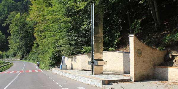
Ten kilometers south from Rakhiv on the right bank of the Tisza there is a point – the result of important measurements of Imperial and Royal Military Geographic Institute (Austria-Hungary was engaged in surveying). In this case it is the so-called old memorial (the ancient label), the location of which was precisely measured on bedrock in 1887. Silver-shiny modern monument of local artist Stephen Kozurak is decorated by “center of Europe“, which may be in elsewhere – depending on how you define the European boundaries.
In the village Dilove of Rakhiv rural district of Transcarpathia there is the geographical center of Europe. 1887 there was installed stone column on which it was written in Latin: “Permanent, precise, eternal place. Very accurate, with a special device, manufactured in Austria-Hungary, on a scale of meridians and parallels, set the center of Europe. Year 1887″.
The village is located 190 km from Uzhgorod and 140 miles from Ivano-Frankivsk. From Uzhgorod minibuses go here 10 times a day. The first run is from the bus station – at 6.30, the last – at 14.20. Length of trip is 5.5 hours.
Dilove is located 50 meters from the Ukrainian-Romanian border. On the opposite bank of the river Tisza – Romanian village Vyshivska Valley of Sighet district. Residents of the two neighboring countries overlap with each other across the river.
– Before the war, the village was called Trybushany – says village head of Dilove Lyudmila Romaniuk – Because there lived three brothers Bushans. And it was later named Dilove because the village was inhabited by business people.
In the nineteenth century in Trybushany there was mined iron ore in the rocks of the mountain Dovharun. Medieval tunnels survived until now. In 1861 Kalman Kagan, a Jew of Romanian town Sighet, also built a glass-blowing factory. There arrived Poles, Czechs, Germans, Slovaks and Italians. They made railway line in the mountains for the Austro-Hungarian.
Engineers have calculated that it must be near Trybushany there is the center of Europe. Scientists of Viennese imperial-royal Academy of Sciences confirmed that there is an overlap of imaginary lines between Lisbon and the Urals, the Caucasus and the North Sea, the Franz Josef Land and the Bosphorus.
Approximately two-meter column is located aside of the road Mukachevo-Rohatyn. It is always full of tourists. Brides and grooms from nearby villages come here to photograph. Nearby there is a museum-inn. There tourists stop to have lunch with Hutsul dishes. The owner of the establishment Vasil Chorbane collected hundreds of old irons, keys, cups and clothes. Near the hotel is being built. For now tourists staying overnight at 18 km – in the rural center Rakhiv or 8 km – village Kostylivka where there are several rural green estates.
Ludmila Romaniuk says that Census of 1935 in Center of Europe there lived 1000 Ukrainians, almost 300 Jews, 200 Hungarians, 60 Czechs and 70 people of other nationalities. The descendants of foreigners – Koradini, Manfredi, Montehloni, Bizi – live here now as well.
The village has four churches. There is also a wooden church of the Dormition of the Virgin, built in 1750. Farmers have gathered money and recently updated frontage. In Dilove there is a marble quarry.
– Kiev Metro was decorated by facing slabs of it. And the crumb of it was used in 1986 on Chornobyl NPP when there was an accident. Marble absorbs radionuclides.
In the middle of the last century in the tract Saulyak near Dilove a Russian geologist Hlynomedov found gold. The deposit is being develop by British and Australians.
– This is the largest gold vein in Ukraine – Larissa shows Street. Mark Barabolya leading to gold mine. – In a month geologists are going to open a processing factory.
The village has a bakery, where bread is baked on the coals, two pharmacies, a branch of the Savings Bank, frontier, clinic and forestry. Here begins walking and car tours to Mount Pip Ivan. Before you go to the mountains, you need to join in frontier because after the mountain it is Romanian territory. On the opposite bank of the Tisza there is a Romanian village Bystryi. Both settlements soon will be connected by bridge. Romanians are building it.
-
 27.02.2024
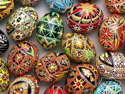
World of pysanka
Embark on a journey into the captivating world of Pysanka, the Ukrainian...
27.02.2024
World of pysanka
Embark on a journey into the captivating world of Pysanka, the Ukrainian...
-
 29.01.2024
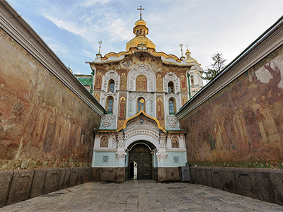
Exploring the Treasures of Kyiv’s Lavra Monastery
In the heart of Kyiv lies the venerable Lavra Monastery, a testament...
29.01.2024
Exploring the Treasures of Kyiv’s Lavra Monastery
In the heart of Kyiv lies the venerable Lavra Monastery, a testament...
-
 13.01.2024
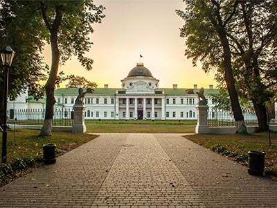
Kachanivka, Eden on Earth
Rich in history, it hosted renowned artists, notably poet Taras Shevchenko.
13.01.2024
Kachanivka, Eden on Earth
Rich in history, it hosted renowned artists, notably poet Taras Shevchenko.