
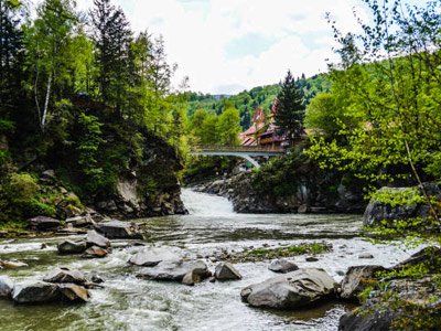
 23.03.2023
Yaremche region, tourist resort
23.03.2023
Yaremche region, tourist resortBackground
For a long time, the Austrian government has considered the Carpathians to be primarily a tourist resort. Different commissions came here to study the surroundings. In the late 1900s the Hutsul villages Dora and Mykulychyn were the most popular among tourists on holiday. In these villages people were treated with Zhentysia (sheep whey). These villages were connected by the road Dellatyn-Yablunytsia, the construction of which was initiated and completed by Franciszek Kratter, Starosta of Stanislaviv (now – Ivano-Frankivsk). The road construction took place from 1826 to 1847, and it facilitated trade between Eastern Galicia and Hungary. A large boulder which hung over the road in Yamna was named after the initiator of the construction. It was called the stone of Kratter and a two-headed eagle and an inscription in German was depicted there.
A railroad, from Stanislaviv to Voronenka and further to Rakhiv, built in 1894 greatly contributed to the development of recreation and the area’s infrastructure. Although it had been built to transport wood, due to its construction, holidaymakers as well patients from Poland, Austria and other European countries started coming to formerly unknown mountains. Within a short period of time dozens of villas were built in Yaremche, Vorokhta and Tatariv. According to Henryk Gasiorowski, in 1928 Yaremche and Vorokhta received the status of public resorts and in the mid-1930s, this territory was annually visited by approximately 25 thousand people. There was even a Warsaw-Vorokhta train to the resort towns of Yaremche region on which people from all over Europe came here for treatment.
The most intense development of recreational and tourist infrastructure was from 1960- 1970. After Ukraine became independent, Yaremche region became a developed resort center of tourism. In the past 20 years, recreation camps and guest houses which provide the whole complex of different services complying with modern demands have been improved.
Town of Yaremche
The town of Yaremche is the most famous tourist resort center of Hutsulshchyna. Ukrainian and foreign visitors have always been attracted to this place by its original culture, architectural sites, picturesque landscapes, mountain peaks, healing springs and silver waterfalls. The town is situated at an altitude of 500-535 m above sea level, 65 km from Ivano-Frankivsk. Yaremche was granted the status of a town in 1963, while in 1977 it was included in the category of cities of Oblast subordination and villages Dora and Yamna were included in its territory. The town consists of 11,469 ha. Its population is about 8,000. Till 2006, the town had two names – Yaremcha and Yaremche. The original name ’Yaremche’ was adopted by the resolution of the Verkhovna Rada of Ukraine. Yaremche was first mentioned in a historical document in 1787. Allegedly, the name Yaremche derives from:
- the name of Yarema Hodovanets, the first settler;
- the surname of the priest Mykhailo Yaremytskyi;
- the stem ‘Yarem’ which means ‘bow’, ‘arch’;
- the Turkic ’to come back’.
The town started developing after the construction of a railway station in 1894. Since XIX century Yaremche was developed as a holiday town (settlement near Dora village), where people came from Vienna, Warsaw, Cracow etc. for recreation. On August 25, 1896 the tourist club ‘Klub Yaremchanskyi’ was created. The members of the club marked pathways for walking in the mountains, built steps to the waterfall ‘Probiy’, marked places for fishing. ‘Klub Yaremchanskyi’ did its best to attract visitors and separate Yaremche from Dora. In 1905-1906 about 1500 people came to Yaremche for recreation in a season.
Since 1911 Yaremche has become a separate unit and about 800 residents lived there. In 1912 there were 2400 visitors in Yaremche. In that year, many journals of Halychyna wrote that the heir to the throne Karl Franz Joseph von Habsburg, who later became Austro- Hungarian ruler Karl I (1916 -1918), stayed in Yaremche.
Since 1928 Yaremche has had the status of a public resort with the prospects of becoming one of the best European resorts. In the mid-1930s, about 6,000 people each season came here for recreation. There was a hotel, a boarding house and three restaurants there and also, a Balneary of Dr. Stanislav Hrader.
Nowadays, Yaremche is the most famous tourist center of Prykarpattia. There are more than 40 recreational institutions and health resorts, upwards of 100 hotels and eco-tourism villas. Climatic treatment, mineral baths etc. are used for therapy in the resorts.
The most interesting of local folk traditions and rituals are Hutsul ‘Rozkoliada’ (Christmas carols), Andriivski Vechornytsi (traditional gatherings with music, songs, jokes and rituals), Epiphany and Kupala feast.
❤️Book a tour to Yaremche today! We deliver everything you need
Village of Mykulychyn
The village of Mykulychyn is situated at an altitude of about 700 m above sea level. Its area is 15,841 ha, population -4,950. This is a low-mountain climatic resort, one of the largest villages in Ukraine. The first record about the village dates back to 1412. According to one version, the village was named after Mykula – the Boyar of Prince Danylo Halytskyi who protected the settlement against attacks.
The village started developing after the construction of the highway. Here, a glass factory and sawmill were established, which lasted until the late 1900s. The village was famous for its wood-processing plants – in the 1930s there were several tartaks (wood-processing plants) where the villagers worked. Sheep breeding was quite widespread, up till now it was an important part of the villagers’ lives.
As a health resort, Mykulychyn was famous for treatment with Zhentysia (sheep whey). By 1927 Vorokhta and Tatariv were a part of it and it was believed to be one of the largest Hutsul villages.
In 1910-1944 a 20.9 km long narrow-gauge railway was built for transporting wood from the mountain areas of Polianytsia Chemyhivska and Kopchyn. The tourists eagerly used the railway to watch the marvellous views of nearby mountains.
In 1901 Lviv Society Narodna Hostynnytsia rented a villa near the railway station from Parson Tadei Halaichuk and opened a Ukrainian hotel where there was a library with a reading room.
Between World Wars I and II, travelers had a choice of where to stay: three tourist stations, a hotel, a boarding house, a health centre of Lviv typographers and health resorts of Lviv academic schools in Mykulychyn. In 1938 the monument to Queen Jadwiga (1374 -1399), the patron of all students, was erected near the latter.
Mykulychyn has always been the centre of production of carved and incrusted (the so- called ‘decorated’) tables. In the early 1920s, a store selling art objects by folk craftsmen was opened in the village.
In the last quarter of the 1920s, numerous children’s holiday camps were functioning in Mykulychyn. After Ukraine became independent, a number of boarding houses were built which comply with the highest demands for recreation. Eco-tourism which involves staying in village cottages is highly popular.
Village of Tatariv
The village of Tatariv is a low-mountain climatic resort, situated at the altitude of 700-750 m above sea level. Its area is 8853 ha, with a population of about 1,500. According to archive data, the earliest record dates back to 1651. Its first name was Prutets. In 1669 the settlement was named Belzets. After the destructive attack of Tatars on the village. In 1673 it was named Tatariv. In the Soviet period the village was named Kremintsi (since 1946) after the Soviet lieutenant who was killed here 111944. In 2000 the village was given its current name.
Old people say that baron Romashkan was looking for natural treatment of tuberculosis when he built stone structures for recreation on the bank of the river Prut. Before 1927 Tatariv was a settlement near Mykulychyn. It was always an important junction, which is why it was regularly destroyed by the invaders. In the mid-1930s, there were 114 households and 600 residents. There was a hotel, a railway, police health resorts (at present – Kremintsi Medical Rehabilitation Centre of Ministry of Internal Affairs of Ukraine) and rooms for rental here.
In the village there is a traditional Hutsul church of St. Dmytrii which dates back to the 1800s and 1900s, a (bell-tower. An interesting tourist attraction is a memorial sign erected to commemorate the Austrian soldiers, killed during World War I.
Nowadays, Tatariv is an important resort where people from different parts of Ukraine come for treatment and recreation.
Village of Vorokhta
Vorokhta have the territory of 1500 ha, its population is 4000, people who are mostly engaged in tourist recreational and wood-processing industries.
The first record of Vorokhta dates back to 1820. A local ethnographer M. Sankovych believes that the name derives from the surname of Mykhailo Vorokhta who settled here at the end of tie) 1700s, while a well-known historian V. Hrabovetskyi is of the opinion that the name derives from ‘Vorokhty’, i.e. the trees which were transported by the villagers to the salteries. In 1700 the name was recorded as ‘wood for a bath-house’. A historian from Lviv, V.Kobyliukh thinks that when translated from Sanscrit ‘Vorokhta’ means a place where wild boars live. However, none of these versions is verified.
In 1918 to the 1920s, the main commercial activity of Vorokhta villagers was cattle breeding, field work and agriculture. It started developing as a resort after the construction of a railroad. The first resort called ‘Persha Sanatoriya’ (The First Sanatorium) was opened in 1906. In the Soviet period it was renamed as ‘Hirske povitria’ (Mountain Air) and it still functions here. Since 1927 Vorokhta became a separate unit and since 1928 it acquired the status of a public resort for people suffering from tuberculosis and lung diseases. In the mid-30s there were about 1500 residents here and the village was considered to have the largest number of health resorts, as there were five of them and they could accommodate more than 300 visitors at a time. The surviving health centers and villas of the 1919s and 1920s, have Interesting construction and ornamental carvings which attracts attention.
Simultaneously, the village was developing as a center of downhill skiing and tourism. In 1930, two ski-jump hills – for children and adults were built, which have become of international significance. Sportsmen from Germany, Norway, Finland and other countries participate in competitions here. The tourists stay at ‘Dvorek Chornohirskyi’ which accommodates about 4000 people annually.
In Soviet times Vorokhta continued to play an important role as a ski resort. Ukrayina Sports Base for skiers and a recreation center for athletes near Avanhard hill were built here. The complex of ski-jump hills remains a popular attraction of Vorokhta. Up until recently, a cable road with a magnificent view of Vorokhta had been operating.
Village of Yablunytsia
The village of Yablunytsia is situated on the border of Ivano-Frankivsk and Zakarpattia Oblasts. Its population is 2,500, with an area of 9424 ha. It is located at altitudes of 850 m to 1288 m above sea level.
Within the village there is one of the main passes of the Ukrainian Carpathians—Yablunytskyi (931 m above sea level), which opens a magnificent view of Transcarpathian mountains.
The history of Yablunytsia village dates back to the 1700s. The first record of the village dates back to 1643 when there was an inn on the way to Hungary. This territory was gradually inhabited by Mykulychyn Hutsuls and in 1688 it appeared under the name of Sloboda. In 1799 the name Yablunytsia appeared in the archives.
Despite the absence of a railroad, the village developed at a fast rate and in the mid – 1830s there were about 1500 residents (together with settlements Voronenko and Polianytsia). In those times Yablunytsia was as popular among tourists as the more famous Yaremche, Vorokhta and Mykulychyn. This was due to its beautiful climate and open territories, which contributed to the development of skiing resorts. Tourists were could stay overnight in villas and open houses.
Up until that time, Yablunytsia village was one of the centers of wintertourism in Prykarpattia and several ski lifts were there. From December to March, one may ski or sledge on the low slopes of Yablunytsia.
One of the attractions is a cross to commemorate the abolishment of statute labor and a mass grave of the soldiers of Carpathian Ukraine who were killed in 1939. At the pass there is a souvenir market.
Village of Polianytsia
The village of Polianytsia is situated in the highlands of the Ukrainian Carpathians in the valley of the river Prutets. The village is situated at an altitude of 860 m above sea level. Its area is 1544 ha, with a population of more than 600. The year when the village was built is still unknown. However, on analyzing the historical data, one may state that the village appeared in the late 1600s and early 1700s, The first settlers were people, fleeing from the Tatar invasion, who settled on forest meadows along the river.
According to folk tales, in the mid XVII Century, a wealthy Gazda (landlord) Popovych from Mykulychyn settled here. Later he became an owner of rural land and the village was named Polianytsia Popovychivska. ‘Polianytsia’ Is considered to be a derivative from ‘polonyny’, i.e. ‘the high-mountain pastures, owned by Popovych’, According to another version, the name of the village designates ‘a burnt place’, The first record of Polianytsia dates back to 1820.
It is known that in 1935 there were 235 members of the parish in the village. There was a church fraternity (both male and female) at the church and a single-grade school. Unfortunately, in 1942 the church burned. Later, the members of the parish built a small modest church there.
The village of Polianytsia is developing at a fast rate because since 2004 a tourist ski resort ‘Bukovel’ (the name derives from the same mountain) functions on its territory.
A tourist route on mountain Khomyak is particularly popular among tourists. A sculpture of Mother of God was erected on its peak in 2006.
Village of Voronenko
The village of Voronenko is situated upstream the river’Paradzhyn near Yablunytsia village. The name of the village Voronenko probably derives from the color ‘voronyi’ (raven-black), i.e. black. The reason for such a name is hard to explain, it might designate the color of the terrain or it might derive from the surname Voronyi.
The village was first mentioned in 1873. The fast development of the village started with the construction of a railroad and a tunnel, and it became a border checkpoint between Poland and Czechoslovakia. The barracks of Border Guard were also situated here.
Although Voronenko was a settlement near Yablunytsia, all its territory was included in the resort Vorokhta in 1928. In the 1930s there were 110 households and about 400 residents there. The number of tourists was small due to the lack of places to stay overnight (people could stay overnight in Hutsul houses only).
Nowadays Voronenko belongs to Yablunytsia Village Council and it is a convenient starting point for climbing mountain Kukul. The interesting attractions in the village are the cemetery of tunnel constructors and an obelisk dedicated to the soldiers killed in World War II.
The most popular peaks of the Yaremche region
The most famous peak of Yaremche region is the highest mountain of Ukraine – Hoverla (2,061 m above sea level). Its neighbors on Chornohora ridge are the mountains Breskul (1,911 m), Pozhyzhevska (1,822 m), Dantsyzh (1,855 m) and Turkul (1,933 m). In the opposite direction, on the territory of Rakhiv area one may see Mount Petros (2,020 m). On Chornohora ridge there are Sub-Alpine and Alpine meadows with crooked forests and unique vegetation which are described in the Red Book of Ukraine. Therefore, this territory is protected by environmental legislation, oversight of which is provided by Carpathian National Natural Park and Carpathian Biosphere Reserve.
Western Gorgany are represented by the mountains Khomyak, Syniak, Malyi Gorgan, Syniachka and Yavirnyk ridge. The large fields of loose rock which are called tsekoty, gregoty or arshytsia are typical here. Below the stone belt there are fields of Mountain Pine (Alpine Pine), i.e. crooked forest.
Mountain Dovbushanka which is situated in the neighboring Nadvirna District is popular among tourists. But it is necessary to remember that all its ridge is protected and tourists can go there only with the permission of Gorgany Nature Reserve administration. Mountains Kukul, Velyka Rokyta and Mala Rokyta, and ridge Lisnovy are attractive due to mountain cattle grazing pastures – polonyny, where tourists can see the uneasy life of Hutsul shepherds.
Rivers, streams, lakes of the Yaremche region
The main river flowing through Yaremche region is the Prut. Its riverhead begins on the northern slopes of Chornohora at an altitude of higher than 1750 m above sea level. Due to the presence of numerous rapids and waterfalls, its main tributaries are of interest – the Prutets Yablunytskyi, the Prutets Chemehlvskyl, the Zhonka, the Zhenets and the Kamyanka. Every year International and all-Ukrainian competitions in rafting and amatour rafting in canoes, catamarans and kayaks are held on Yamna canyon – Probii waterfall section of the river Prut. In hydrologic network of Subalplne landscape 1-1.5 m deep lake Nesamovyte of glacial origin is particularly beautiful. Its area is 0.3 ha, and it is situated near the foot of mountain Turkul on Chornohora ridge.
Waterfalls of the Yaremche region
There are several waterfalls on the territory of Yaremche region:
The largest is 11 m high Huk waterfall which is on the stream Zhenets near Mykulychyn village (Pidlisniv settlement);
Probiy waterfall on the river Prut is situated in Yaremche near the souvenir market Probii waterfall is a picturesque place. In old times the height of direct fall of water was more than 8 m. In 1840 the waterfall was twice partially blown up in order to raft wood in the river Prut, but the desirable result was not achieved, however, the natural monument was spoiled. Its pit is 20 m deep; the current speed is 50-70 km per hour.
Another waterfall – Divochi sliozy (Maiden’s tears) is a favorite tourist spot which is situated in the forest on the river Zhonka (tributary of the river Prut), it is 1.8 m high.
The cascade of waterfalls on the Prut near Hoverla;
Kaplyvets waterfall was finally destroyed in 2010 due to a rockslide.
Springs of the Yaremche region
In the territory of Yaremche District, there are numerous mineral water springs, namely chloride, carbonate, sulphate, hydrocarbonate mineral waters of types ‘Borjomi’, ‘Narzan’, ‘Yesentuk’, ‘Arzni’. Especially famous are carbonate sodium hydrocarbonate and calcium waters, the so-called ‘Burkut’.
Springs of Yaremche District:
- In the recreation zone ‘Rebrovach’ (Vorokhta)
- Near m. Pozhyzhevska
- In the recreation zone ‘Hoverla’’
- In Yaremche near the river Zhonka
- In Yamna (near the road)
- Behind Vorokhta near the road leading to Verkhovyna
Bridges (viaducts) of the Yaremche region
An engineer Stanislaw Kosinski designed a 205 m long, 28 m high railway bridge, with the bridge span of 65 m in Yaremche.
It was partially destroyed by the retreating Russian troops in 1915. In 1927 the Polish authorities restored it to its original state.
The bridge was blown up the second time by the retreating German troops during World War II.
Vorokhta viaducts are three railway bridges built in the 1900s, through which the first railroad was built. Two bridges are still in use, while the third (the longest -125 m) was replaced by a modern concrete bridge. One of them is considered to be the first bow-shaped bridge in Europe. In other settlements similar bridges were destroyed in World War II.
Natural sights of the Yaremche region
The rocks of Dovbush (mountain area Drlbka) are a unique creation of nature which have long been a real tourist ‘mecca’. A unique pile-up of rock mass of Yamna sandstone has been there since the Ice age and a fortress of a unique style was created here by corrosion and decay of rock.
The stone of Dovbush near the highway and tunnel is of particular interest. The silent giant stands high over the Prut, steeped in. legends and folk tales. It is decorated with a stone cross and it seems that at its foot the legendary rebel sleeps in his grave.
The stone and the rocks of Dovbush are natural sites connected with the name of a legendary leader of rebels Oleksa Dovbush who acted in Prykarpattia in 1738-1745 as a head of Halych ‘opryshkivstvo’ (a particular form of fight against social and national oppression from 1905 to 1908.
There is a famous impressive-looking geological rock exposure in Yaremche over the Prut called ‘Elephant’ as its outlines resemble a large animal with a trunk. This is a 60 m high vertical Flysch rock which plunges to the river.
Rock Bilyi Kamin – (White Stone) on the outskirts of Dora, rocks on Gorgan (Kostel) mountain near Mykulychyn, rocky landscape of Kizla (Chornohora) mountain are of interest. There are unique monuments of nature here: Rebra mountain , a rocky peak of Shpytsi mountain, traces of ancient icing – Zarosliatskyi kar and an erosive glacial kettle Role between Hoverla and Breskul.
-
 27.02.2024
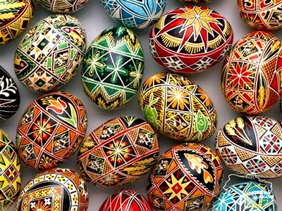
World of pysanka
Embark on a journey into the captivating world of Pysanka, the Ukrainian...
27.02.2024
World of pysanka
Embark on a journey into the captivating world of Pysanka, the Ukrainian...
-
 29.01.2024
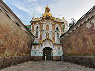
Exploring the Treasures of Kyiv’s Lavra Monastery
In the heart of Kyiv lies the venerable Lavra Monastery, a testament...
29.01.2024
Exploring the Treasures of Kyiv’s Lavra Monastery
In the heart of Kyiv lies the venerable Lavra Monastery, a testament...
-
 13.01.2024
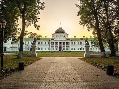
Kachanivka, Eden on Earth
Rich in history, it hosted renowned artists, notably poet Taras Shevchenko.
13.01.2024
Kachanivka, Eden on Earth
Rich in history, it hosted renowned artists, notably poet Taras Shevchenko.